

BBC – Travel – In Guatemala, the Maya world untouched for centuries
[ad_1]
There is no path through the jungle. Every step requires navigation: winding around a tree; stepping over a root; ducking under a branch. In front of me, a man swings a machete, trying to cut an easier path.
“Don’t touch anything,” my guide, José María Anavisca, warns me. You can’t be sure what snake or spider or other creature might be on a branch or tree. Despite my caution, I soon feel a sensation on my back, somewhere between being pricked and electrified, and wriggle in shock. “An ant,” Anavisca says knowingly. I hope he’s right. Whatever it is, it’s dropped under my collar and taken a bite.
It’s 32C and 100% humidity, typical for Tikal, Guatemala in June. Where we’re going looks exactly like where we came from, a tangle of green, glossy leaves spiked with elegant trunks. We stop several times, turn, retrace our steps. “Are we lost?” I ask finally, wiping sweat from my forehead.
“No, no,” Anavisca says. He grins, quipping: “The Lost World” – one of Tikal’s best-known ceremonial complexes – “is that way.” I’m not sure how he can tell.
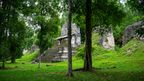
Tikal
Once the greatest city in the Maya world, today Tikal is Guatemala’s most famous archaeological site. But even on the well-trodden, signposted tourist route, it’s impossible to forget you’re in the rainforest. Birdsong fills the air, spider monkeys loop across the treetops, and at dusk, the area around the Lost World is taken over by coatimundis – long-tailed, raccoon-like mammals that nose through the ground for insects.
Today we’ve gone off the beaten track completely. Anavisca wants to show me something few tourists see, and which far fewer would recognise: a Maya pyramid, unexcavated and overgrown with jungle.
I wouldn’t know that we’ve arrived if Anavisca didn’t tell me. The jungle looks no different than it did before. But under our feet, a slope suddenly tilts steeply upward. Anavisca points to the map he has brought. Sure enough, we appear to be standing on a distinct pyramid. “It’s still in its natural state. It hasn’t been excavated. It hasn’t been investigated,” he says.
It’s still in its natural state. It hasn’t been excavated. It hasn’t been investigated
Anavisca and his colleagues, who work in archaeology and conservation at Tikal, have long suspected that this hill is a pyramid. But it wasn’t until recently that proof came in the form of Lidar – a type of remote sensing technology currently transforming archaeology. It was Lidar data that went into the map Anavisca is now holding.
By stripping away the jungle canopy and revealing the topography beneath, including long-forgotten sites and monuments, Lidar has been especially helpful in jungles like this one. The Maya Biosphere Reserve covers 21,602 sq km – nearly one-fifth of Guatemala – of forest, wetlands, rivers, lakes and savannas. It is the largest protected rainforest north of the Amazon. It also was once the heart of the Maya civilisation, whose city-states ruled Central America from about 750BC until the Spanish conquest of the 1600s. But the jungle makes structures particularly difficult to find, or identify.
“The Lidar makes it so that, as archaeologists, we don’t have to spend all of our time just figuring out what’s there – and instead, we can really focus in and excavate and address questions that we want to,” says Thomas Garrison, a Maya archaeologist at the University of Texas at Austin.
“So much of our time is spent mapping and just trying to find places. And what Lidar has shown us is that we weren’t very good at it.
Lidar works by beaming lasers at a site – whether up close, from a hand-held scanner; or at a distance, such as from an aeroplane. By measuring how much time it takes for the laser to return to its point of origin, it can create extraordinarily detailed maps and 3D representations.
Using Lidar, in 2016 the Foundation for Maya Cultural and Natural Heritage (Pacunam) launched the largest archaeological survey ever undertaken of the Maya lowlands. In the first phase, whose results were published in 2018, they mapped 2,100km of the Maya Biosphere Reserve. Their hope in the further phases – the second one of which took place in summer 2019, while I was there – is to triple the coverage area. That would make the project the largest Lidar survey not only in Central America, but in the world.
Researchers are still combing through the 2019 data. But the results from the first phase have already shifted how archaeologists see the Maya civilisation. “There are three to four times as many structures in the landscape as we had thought,” says Garrison, who is also one of the researchers for the Pacunam Lidar Initiative. The 60,000 structures that were revealed included temples, pyramids and causeways.
But the majority of the structures were platforms for houses, a crucial piece of information for population estimates. Previously, experts had projected that, at the peak of the Mayan Classical period from about 250-900AD, about one to two million people lived in the cities and towns of the central lowlands. Now, experts believe the area supported up to 11 million inhabitants.
That larger population was supported by an even more sophisticated infrastructure than experts had previously understood. The Maya connected their cities with raised highways; and they made the land usable, and sustainable, with complex irrigation and terracing systems.
“The Lidar shows, without any doubt, that we totally underestimated their engineering capabilities in terms of landscape modifications – to make the land more sustainable, to irrigate and bring water to places they could cultivate, to stop erosion,” says Francisco Estrada-Belli, a Tulane University archaeologist and one of the co-directors of the Pacunam Lidar Initiative.
That has turned one common belief on its head. An enduring mystery of the Maya has been why their civilisation declined. For years, a popular theory has held that it was due to environmental collapse, thanks to the Maya deforesting and degrading the surrounding landscape.
“All the things that we blamed them for – they destroyed the soils or had to put in terraces – it’s quite the opposite,” Estrada-Belli says. “They built the terraces to increase the productivity of the soil, obviously stopping the erosion. And they irrigated areas that were flat, but they didn’t have enough water. They drained the wetlands so they could cultivate them, and it was the most productive land ever.
“And they did that on a massive scale.”
El Zotz
The ancient Maya city-state of El Zotz, now an archaeological site where Garrison is director, is 23km from the nearest town. It feels further. The drive takes 2.5 hours; the last hour is on a muddy track through the jungle. Our beaten-up pickup truck, which is also bringing supplies to the archaeologists’ camp, gets stuck at one point going up a small slope. The wheels whir. We go nowhere. The driver tries again. The tyres spin in the mud.
Two of the guys in the truck jump out, cut some palm fronds down with a machete and lay them on the track to make it less slippery. After a couple of tries, we make it. Despite the scenarios spinning through my head – what if we get stuck here?, there isn’t any mobile phone reception. When would the archaeologists at the camp, who know to expect us today, send a search party for us? How much water do we have? What if the storm that’s been looming on the horizon finally breaks? – no one seems concerned.
When we found it, the chamber was completely sealed
Later, I learn from Estrada-Belli, who is also the project director of the equally remote Maya site of Holmul that it could have been worse. In his first season at Holmul, in 2000, he took a wrong turn driving in the jungle and got stuck. “The engine basically seized on us. We had to put all of our drinking water in it. We were out of car, out of drinking water, in the middle of nowhere. That was the first day.”
Although they made it back to the site, it soon began to rain. And rain. The 40 people staying at the camp were stuck. The roads were too flooded to drive. To get home, the team had to get out of the jungle on 20 horses. “I had all these people – some of them were my students – and we were stuck out here with no medical help, no way to communicate,” Estrada-Belli says. “I was a little worried.”
Adventures still happen. Over the years, the research teams at sites like El Zotz and Holmul have built more and more of an infrastructure. At El Zotz, one hut doubles as a research lab, plastic tarp thrown over any findings when they’re not being handled to protect them from the humidity. Another thatched-roof hut houses the kitchen, where meals are cooked over an open fire. The team filters their own drinking water. Everyone sleeps in tents. I’m woken each morning at 05:00 by the roar of howler monkeys, who sound like dinosaurs straight out of a Jurassic Park film. When I dress, I have to remind myself to shake out my shoes for scorpions, seven species of which make their home in the reserve.
If it takes effort to drink water or cook or dress at a Maya site like El Zotz, it takes even more to do research. If you want to examine or map an unexplored area, there are no roads or tracks, no detailed maps. At the camp, there is no internet connection; for mobile phone reception, you have to hike 500m to a hilltop. The only resources for making sense of your findings are the other team members and any research you’ve brought with you.
“If you want to erase the exterior world, it’s easy – you can be here for a month without not knowing what’s going on,” says archaeologist Edwin Román, who has helped lead investigations at El Zotz for the last 10 years and is director of the South of Tikal archaeological project.
Now, at El Zotz, Garrison and I pull up to what looks like another tree-covered hill. I’ve spent enough time with archaeologists here now to know it’s a pyramid. I duck through the tunnels behind Garrison, turn a corner, and gasp. Nothing quite prepares you for seeing a Maya carving looming out of the dark.
In this case, it’s the monumental mask of a Mayan god, looming higher than I am tall and dating to the 5th Century AD. Garrison’s team thinks it marks the platform for the crowning of new kings. “At Maya sites, when new kings would come into power, there’d be a big ceremony and ritual – like the crowning of a king in England,” Garrison says. “This is the god that would preside over that ritual.”
Later, I follow Román to the nearby site he is investigating. Called “El Diablo” (the devil), it requires a steep hike up to the top. The temple here was built on top of the 4th-Century tomb of the first king of El Zotz – something Román discovered in 2010. “When we found it, the chamber was completely sealed. When we opened it, there was, like, a cold breeze – like the smell of putrefaction,” he says. “The entire tomb was there.” Along with the remains of the king, they found the bones of six sacrificed children.
I follow Román through a tunnel into the pyramid, up a wooden ladder, through another tunnel. We wind up just above where the remains were found. Another work of Maya art spreads before me: a series of monumental carvings that spiral across the stone, punctuated with massive masks that depict the gods of the Sun. The faces are striking. The eyes gaze with intense swirls; the noses are large and lumpy. One is the god of the rising Sun, his eyes still with remnants of black paint. Another, painted red, represents the sunset. By associating the king with the Sun, says Román, the Maya were associating him with eternity. While it may not be eternity, there is still something poetic about viewing that depiction, still in all its glory, 1,600 years later.
These masks were found the old-fashioned way: with manual mapping, surveying, identifying and digging.
But Lidar has helped archaeologists put the pieces together. Román and the other researchers knew, from glyphs and from the monumental sites they had found, that the king buried at El Diablo was powerful. “But we didn’t know the extent of his power,” Román says. Lidar revealed the workings of the whole city-state: its massive fortifications, its farms, its water systems.
“The Lidar is now helping us to see everything this king made to protect, him, his family and his legacy,” Román says. “Lidar has helped us to understand the entire landscape, everything that they built, so we can have more of a sense of it.”
That understanding also complements the stories the Maya have handed down to us. One aspect that makes the Maya unique is their writing. “They’re the only civilisation in the New World with fully developed writing system, so we actually get their voice to complement the archaeology. It’s not just us interpreting it,” says Garrison.
“These different kings would go to war with one other – it was a sort of Game of Thrones style combat. Marriages, alliances, all these sorts of things. We know that from the texts – and now the Lidar has revealed this landscape where this drama unfolds. So, we get to see all of the places that would have been involved in ways that we couldn’t before,” he says.
In some cases, the Lidar findings also have corrected the data that archaeologists spent years collecting. “The Lidar showed long causeways between sites 7km long. We drove across them, we walked across them, we had no idea,” Estrada-Belli admits. “I mapped a section of a causeway thinking it was a 100m-long wall – and had no idea that it continued for 7km as a causeway, not a wall.”
Even more extraordinary is the time it saves. It can take an archaeological team a year to map an area 1km square. In contrast, it took just 10 days for the planes involved in the Pacunam Lidar Initiative to collect enough data to map a 2,100km area.
“It’s very humbling because you’ve been mapping, and you think you know what you’re doing – and it’s so much better than anyone, than any of us, can do,” Estrada-Belli says. “It can do what we do in 20 years, in two days. The same work, and it’s better. It’s more detailed, and more accurate.”
Holmul
On my first day at Holmul, a Maya city-state that was most active from 800BC to 900AD, Estrada-Belli drives me out to the site. The track here is in even worse shape than the one at El Zotz. Which means I’m surprised to see, a few minutes from the camp, that we have company. A truck lies flipped over beneath the trees, bright orange and impossible to miss. Also impossible to miss: the bullet holes that have pierced it.
“The one in the front is from a rifle,” Estrada-Belli says, a little nonchalantly. “Apparently there was a shootout among looters, and they left that behind.”
We walk to a clearing. It looks like a scene from Indiana Jones. Wooden stairs climb up a steep hill overgrown with jungle. An age-blackened stone wall with a portal is set into the hilltop. I follow Estrada-Belli inside, through tunnels pitch-black except for our flashlights. When we pause at the top of a wooden ladder, he flips a switch, turning on a solar-powered light.
The Maya believed everything had a soul, including images of people and things
A colourful frieze unrolls below me, 8m in one direction and, around the corner, 5m in the other. It was carved around 595AD to honour a king who had just died; he was buried in a tomb beneath. Glyphs run along the bottom, telling you exactly who this was for and why. On the corner, a king stands in sculpture. Estrada-Belli found his remains in a tomb below.
The frieze was part of a funerary shrine which may have been used for 50 or 100 years before it was buried by 8m or so of rubble. That has preserved not only the carvings, but – even more unusually – the paint. The background is bright red, made from haematite. In the sunshine, it would have sparkled. Other details are painted in green, yellow, blue. One king wears a headdress with green feathers from the quetzal bird. The guardian of the night sky has blue under his eyes, as if he’s tired.
The frieze is almost immaculate, except for one thing: the king’s face has been broken. “It’s been damaged on purpose by the ancient Maya,” Estrada-Belli says. “The Maya believed everything had a soul, including images of people and things. So, when they were burying something, they would let the soul out by killing the image – just like you kill a person.”
It’s extraordinarily lucky that it isn’t more damaged than that. Looters got here before Estrada-Belli did. “They missed the structure with the frieze by 20cm,” he says. He points to the tunnel. Just one rock lies between it and the top of the corner statue. “You can imagine what they would have done. They would have thought, ‘There’s definitely something cool behind this carving’, and they would have just blasted through it.”
Antiquities trafficking was tied to the drug trade. “They would clear the forests around the archaeological sites, plant the marijuana, loot the sites while the marijuana was growing – and then collect two harvests,” Estrada-Belli quips.
Looting is less of a problem today than it once was. Still, protecting the sites remains difficult. Even before the coronavirus crisis, there were about 180 park rangers and military personnel throughout the reserve. That meant one guardian per 120sqkm of jungle – an area larger than Manhattan, or Paris. The remoteness of the sites makes them even more vulnerable.
This is one other way the Lidar may be able to help: by providing an extensive inventory of what the jungle actually has. The resolution is so high that you can even see the cuts made by past looters.
“In the Lidar data, we’ve seen scores of new sites that we didn’t know about,” Garrison said. “But, you know, to say we’ve discovered them is a little bit inaccurate – because clearly someone’s already been there.”
The “underworld”
I have one last site to see in the Maya Biosphere Reserve. Another of Holmul’s royal funerary temples, this one dates to 150AD. When it was found, it was the oldest Maya temple still standing.
Estrada-Belli and I walk around it: it’s been carved to make it look like an incense burner, which would have been a sight to see when it was filled with smoke. His team can be sure about its use because there’s an inscription on it saying so. “It’s very rare for archaeologists to find the exact answer to the question ‘What is the function of this building?’,” Estrada-Belli says with a chuckle. “God bless them, they didn’t want to leave any doubt about what they were building these structures for.”
Welcome to the underworld
In 1909, a team of Harvard archaeologists excavated the site and found 22 skeletons. But they didn’t find everything. After a few seasons at Holmul, the expedition director, Raymond Merwin, became too sick to continue. He had contracted a mysterious illness in the jungle, the result of a bite from a particular parasite-carrying insect. (“Are these still around?” I ask nervously. “Yes. It’s called the assassin bug,” Estrada-Belli says). His notes were left incomplete; excavations ended.
Until Estrada-Belli and his team came here a century later. When they did, they made an extraordinary find. Beneath the 150AD temple, they found an even older one, built all the way back in 350BC. No one has ever found an older temple in the Maya world.
We walk around to the side to enter it. By this point, I’ve crawled through tunnels, climbed up ladders, wedged myself around narrow corners and lowered myself through holes. This is the first time I’ve seen a door. Estrada-Belli puts in a key, turns it. The door creaks ominously as it opens. “Welcome to the underworld,” he says with a grin.
Down a set of stone stairs, a frieze opens up before us. It would have been the front exterior of the old temple. It measures about 3m by 2.5m. It doesn’t have the colours of the last frieze; it’s a little less elaborate than the masks from El Zotz. But it takes my breath away.
The frieze depicts the massive head of an Earth monster, its mouth open and teeth bared. Inside the mouth is an old man: the god of the ancestors. He has heavy-lidded eyes, whiskers, a tooth on either side of his mouth. Wrinkles are drawn as lines along his cheeks and nose. He looks, somehow, peaceful.
“The first impression was that he’s been devoured by the Earth and he’s dead. But actually, if you look closer – there’s a hand over there, and another hand over there – he’s emerging from the place of the dead,” Estrada-Belli says. “It’s about death, but it’s really about life.” The god of the ancestors is pulling himself from the place of the dead, head-first, like a baby coming out of the womb.
On the side of the man’s face are two tiny handprints: a child’s. It seems there was a ritual where a child’s hands were placed on the old ancestor, a sign of the new and the old. And next to the old man is a skull and crossbones, the oldest depiction of a skull and crossbones in the world.
Even today, the Maya in Guatemala worship a god of the ancestors. They depict him in the same way: the wrinkles, the whiskers, the two teeth. And, like those 2,500 years ago, they believe children are ancestors who return to the world.
Friezes like this one have been captured with hand-held Lidar scanners that create detailed, 3D models, allowing archaeologists to inspect them in new ways. And the Pacunam Lidar Initiative has meant that sites like Holmul – and El Zotz, and Tikal, and the dozens of other abandoned cities strewn across the Maya lowlands – are being understood in new ways, including how their rulers and citizens interacted, traded and warred.
Centuries after the deaths of kings, dynasties and whole civilisations, Lidar is breathing new life into their stories – and, hopefully, extending their memory for millennia to come.
—
Reported, presented and produced by Amanda Ruggeri
Principal filming by Monica Wise Robles
Editing by Monica Wise Robles, Rafael Camacho and the Travel Show
Sound mix by Glenda Charles
Colour correction by Paula Jiménez and Mariano Villegas
With thanks to Francisco Estrada-Belli, Edwin Román, Thomas Garrison, José María Navizca, Fredy Molina Sanchinel, Enrique Fosado, Marianne Hernandez and Pacunam
Future of the Past is a BBC Travel series that explores important cultural heritage sites around the world that are under threat, and the innovations – both human and technological – being used to save them.
—
Join more than three million BBC Travel fans by liking us on Facebook, or follow us on Twitter and Instagram.
If you liked this story, sign up for the weekly bbc.com features newsletter called “The Essential List”. A handpicked selection of stories from BBC Future, Culture, Worklife and Travel, delivered to your inbox every Friday.
[ad_2]
SOURCE NEWS

